54.40194364604, -1.7373260359655
Wessex Archaeology was commissioned by English Heritage to undertake a geophysical survey to understand more about the history of Richmond Castle, one of the earliest Norman fortresses in England, as part of their programme of reinterpretation.
The challenge
Richmond Castle is one of the best-preserved examples of Norman enclosure castles in the country. English Heritage look after and manage the site, and their interpretation of the castle was a little tired and needed refreshing. Despite having a reasonably well-understood history from sources in both local and national archives, Ordnance Survey (OS) mapping and previous evaluations, as well as from English Heritage’s historians, the site could benefit from more human stories to bring it to life for the public.
“Richmond Castle is a fantastic site with a varied and interesting history,” explains William Wyeth, English Heritage Properties Historian. “We worked with Wessex Archaeology to understand more about how the structure evolved, which will help us tell some of the more human stories of the castle. The aim of the project is to inform our interpretation of the site so that we can bring it to life for visitors.”
Excavation by its very nature can be destructive, so it rarely gets performed in castle grounds, and sites like Richmond are legally protected scheduled monuments, excavation on these sites is quite rare.
Geophysicists on the other hand specialise in non-invasive methods of detecting what can be found beneath the soil, and this can offer an effective method for investigating a sensitive, multi-layered site.
Objectives
The aims of the survey were to conduct a detailed survey covering as much of the area as possible; to clarify the presence/absence and extent of any buried archaeological remains within the site; and to determine the general nature of the remains present.
Our approach
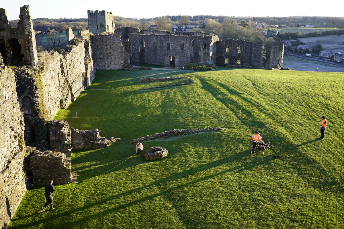
In order to see what might survive within the central courtyard, Ground Penetrating Radar (GPR) was deemed the most appropriate method of survey. The technique works by sending radar waves into the ground. Buried features like walls and cellars can be located by measuring the response detected. GPR is ideal for sites where buried foundations might exist.
The GPR survey was conducted using a Malå RAMAC monitor and control unit with a shielded antenna. This was mounted on a rough terrain cart which is fitted with an odometer to measure horizontal distance along the ground surface. The cart was pushed manually in the zigzag method across the site, and data was collected along traverses spaced 0.5 m apart. This ensured that no features would be missed, such as narrow foundations or smaller objects.
Each traverse generates a profile of what lies in the ground at different depths. These differences can be as simple as a variation in the amount of water in the soil, building foundations, or buried surfaces. Individual profiles can be difficult to interpret and require expertise to understand. By combining all the profiles together into a 3D model, the profiles can start to make more coherent sense. This model gives us a vertical view of all our horizontal profiles at once. In this instance it has proved a useful tool.
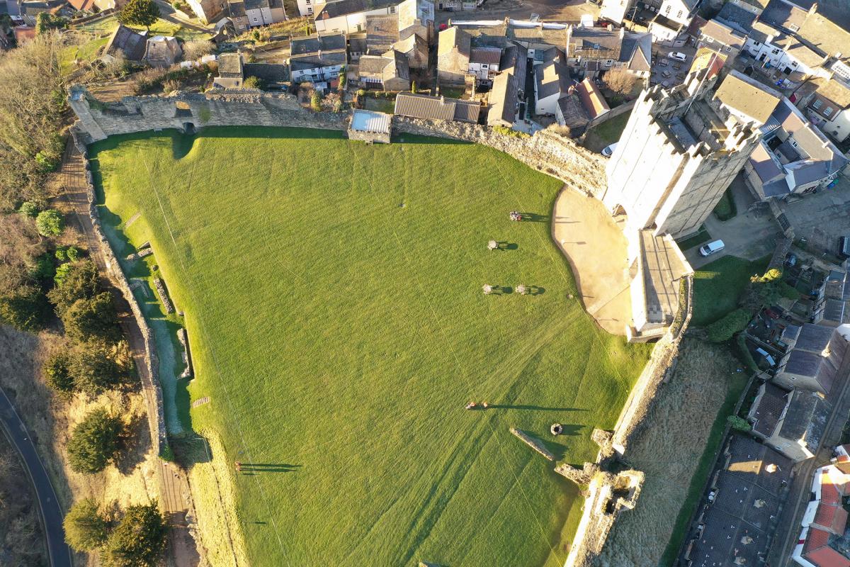
Alongside the geophysical tools, Wessex Archaeology deployed an Unmanned Aerial Vehicle (UAV) to help document the survey area. Having a bird’s eye view is an excellent way to find archaeology and archaeologists have used aerial photography since its inception to search for and document sites. Often archival photos are used to help indicate potential for archaeology within a landscape, as commissioning new aerial photography was very expensive. Now, thanks to the UAV and satellite imagery, high quality aerial photography is now utilised on almost every site.
The methods and standards employed throughout the geophysical survey conform to current best practice, and guidance outlined by the Chartered Institute for Archaeologists’ (CIfA 2014) and European Archaeologiae Consilium (Schmidt et al. 2015).
Survey results
After scanning the area using GPR, the Wessex Archaeology team assessed the data and identified several structures of interest.
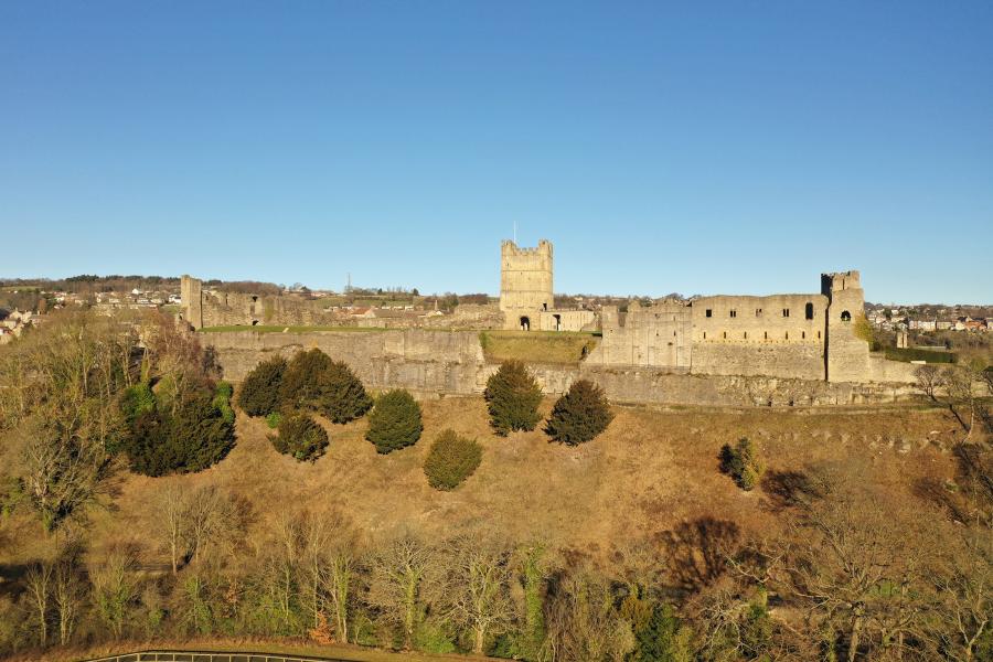
The grassy interior of Richmond was captured photographically with the UAV and provided a great example of aerial prospection, with shadows and surface undulations more visible from the air giving clues about the former buildings on the site, including the 19th century barracks. Before its demolition it served as social housing, and before that barracks for the Non-Combatant Corps during World War One. The contemporary cell block, which housed the ‘Richmond 16’, still stands next to the keep.
The results from the survey showed the barracks building very clearly along the western edge of the survey. The eastern side of the survey revealed a variety of building foundations which are probably related to earlier structures and other areas of possible rubble and foundations suggest a greater number of stone structures present in the courtyard than previously assumed. Further to this, modern features including several service pipes have been confirmed across the site.
The castle is an early Norman enclosure castle and is notable for the excellent state of preservation of its 12th century keep and survival of its 11th century features. It occupies a naturally defensive position on a cliff above the River Swale, and includes the standing remains of the castle, its three courts, castle bank and areas of surviving castle ditch. The earliest form of the castle was that of a massive curtain wall around two sides of a triangular central court (castle garth).
The documented history of Richmond Castle began sometime after 1071 when Count Alan Rufus ‘the Red’, a Breton cousin of William the Conqueror, took possession of the estate, with the earliest surviving buildings at the site likely erected c.1080. Rufus’ great-nephew, Duke Conan IV, would undertake a major expansion of the castle in the mid-12th century, probably also including the construction of the keep that can still be seen today.
While Richmond castle had some strategic value, more important was its role in the administration of the vast estate it oversaw called the Honour of Richmond, which underwent numerous changes of lordship during the Middle Ages and after. It owes its excellent state of preservation to it being overlooked by the Wars of the Roses and the Civil War. The castle had some investment during the 15th and early 16th century, but by the 17th and 18th century the castle was largely a ruin.
During the 19th century, the castle became a depot for the North Yorkshire Militia. Married quarters were built on the west side of the great court to house militia staff sergeants and their families based in Richmond. The militia buildings were reused by the Green Howards regiment and later by the Non-Combatant Corps during the First World War, culminating with the married quarters being demolished in 1931. From 1911, the castle gradually came into state guardianship, and almost no evidence exists for how the interior grounds looked aside from the keep and great hall.
During the First World War, ‘The Richmond 16’, a group of conscientious objectors, were detained at the castle.